Phannie

Phannie
Photo taken near Monument Valley, Utah

Thursday, September 24, 2020

Where Are We Now?

 At Circle the Waggins RV Park, La Veta, Colorado...

Well, sorry I sort of left you hanging after we made our break from Washington State. We have put quite a few miles behind us since then on our way back to Texas: Spokane, Butte, Pocatello, Salt Lake City, Durango and now, La Veta, Colorado. These have been mostly one- or two-night stays, and it's not easy to come up with something worthy of a blog post with such short stays. Fortunately, there are already posts in the blog for Butte, Salt Lake City and Durango, so I haven't exactly left you empty-handed. All you have to do is search on the city names.

So why, you may ask, do you feel the urge to post about tiny La Veta, Colorado when this is also only a one-nighter? Well, two reasons:  1) There may be a handful of readers who wonder what we're doing and 2) La Veta was far more interesting than I thought. We got here over the famed 10,800-foot Wolf Creek Pass (also the Continental Divide) and, I must say, the drive down 160 from Durango was simply beautiful. I could have stopped at a dozen places and taken some great mountain photos, but we already have dozens of photos of beautiful mountain scenery in many different locations, so I decided not to take the effort to find places to pull off the road with the 65 feet of vehicles we were driving. We are also eager to get back to Texas in order to have Sandy's foot surgery done. She has suffered far too long, and I suppose that was part of my thinking.

Admittedly, there are other issues. We know we're going to be transitioning to part-time status soon, given that we are having more joint problems (my knees need attention rather badly). But there are other reasons we're making the change. By the time we make the changeover, we will have been RVing for 16 years and fulltiming for five years. Things have changed a lot in that time. First of all, we've just about fulfilled our bucket list and, at the time of this writing, I can't think of a state we haven't at least traversed. Secondly,  many of our formerly fulltiming friends have left the road, so we aren't able to get together with them nearly as often. A third consideration is the difficulty of finding RV spaces in parks we prefer. The RV manufacturers are turning them out by the hundreds of thousands, and few new RV parks are being built to accommodate them. And lastly, we know it's time. It's sort of like before Sandy and I retired; we would ask our retired friends, how do you know when to retire? Invariably, they said, "You'll know." And we did.

Verifying my frustration at finding RV spaces, I wanted to stop desperately at Moab and take a look at Arches and Canyonlands National Parks again but, alas, there was no room in the inn. Moab was covered up with tourists! The best I could do was to get a photo of an arch south of town as we headed to Durango:


Just because we're changing from fulltiming, that doesn't mean we're getting rid of Phannie. As long as we're able, she will handle our part-time journeys--I'm sure as faithfully as she has for the last 11 years she has served us so well. 

What we don't know is what--or where--our not-on-wheels home will ultimately be. That, of course, has been on our mind as well, so we'll have a number of things coming up that will be occupying our time and thought.

With that out of the way, allow me to chat about La Veta for a bit. This little one-horse town is a first visit for us and, from the looks of it, there wasn't much to expect. However, it is one of the last towns where we will see vestiges of our beloved Rocky Mountains, and highway 12 that runs through it is one of Colorado's Scenic Byways--and for good reason. We got here early enough to do some driving around, and we found some pretty fascinating geology, that I'll briefly describe. First of all, let's get downtown La Veta out of the way--a cute little town, quite rundown in places, and some of the streets are dirt. But the vibe was a little Santa Fe-ish--maybe a hundred years ago!


Driving out Route 12, we ran into some interesting mountain features that we happened to learn a little about by reading roadside signs.


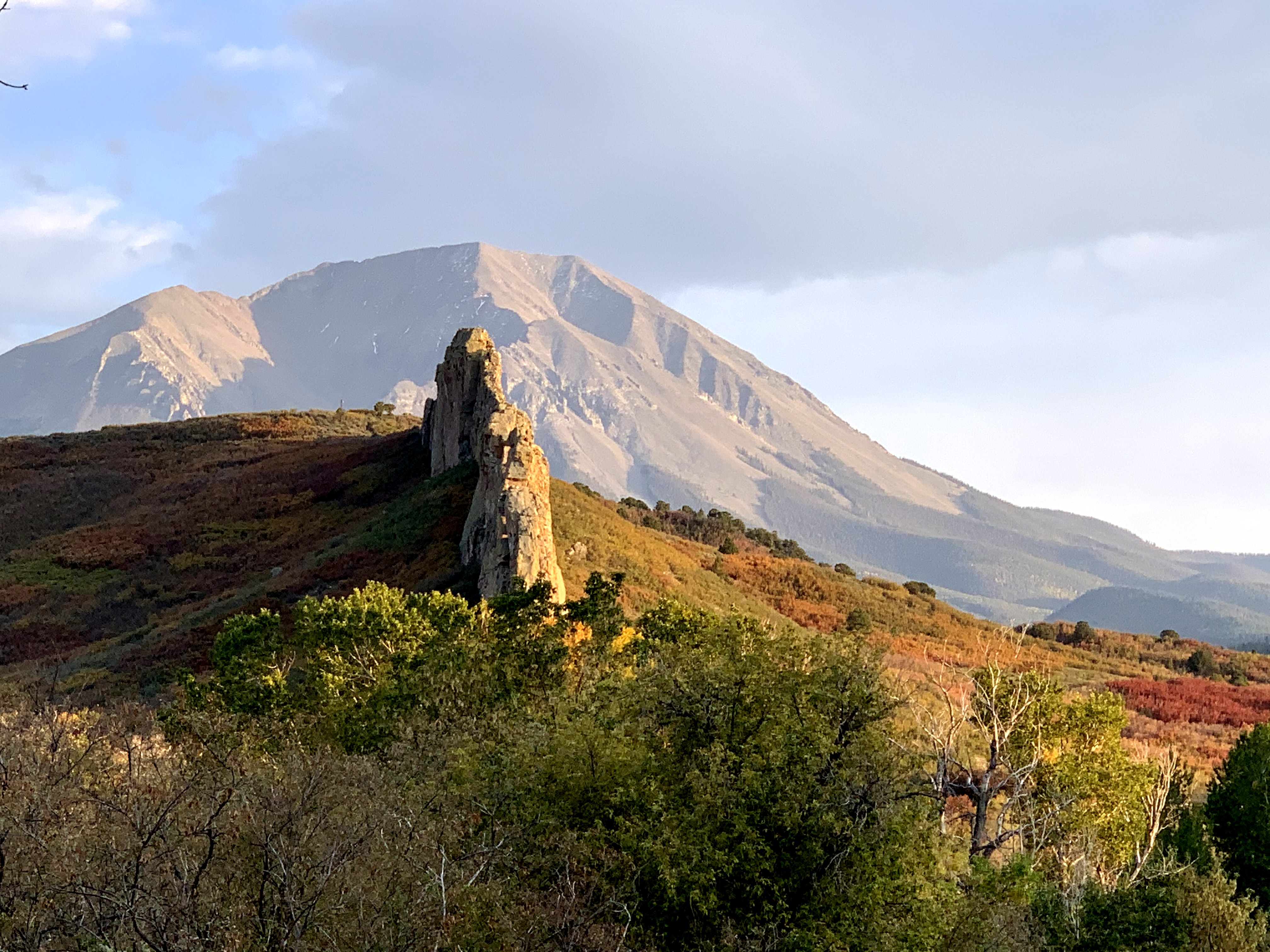
First, there was the East Spanish Peak (or the West Spanish Peak; I'm not quite sure which it is) shown above which, at about 13,000 feet, I hadn't seen before. Notice the protrusion of rock above the trees in the lower left of the photo. I don't pretend to be a geologist, but I have read that this is harder rock than that around it, so it erodes more slowly. The interesting thing about this is that it forms a sort of backbone line that can be seen in the next photo. I'm sure there's a much more esoteric explanation available from someone less ignorant of geology--like my friend and geology professor Pat Sharp, for example. I'll get her take on it one of these days.


Here is the end of the backbone that I found interesting with colorful vegetation around it:


According to the information on the road signs, this is what's left of a volcano that failed to erupt, although it came close. The protrusion above the ground, presumably, is the magma that entered the throat of the fissure but chickened out. Since it is harder rock than that which surrounded it, its erosion has been slower:


We love anything to do with folklore, so take a look at the photo below:


Taken at a very long range, you can see stones protruding from the mountain that form a stairstep pattern. You may be able to see them better in this next one:


According to the information on the roadside signs, ancient Indians believed this was the stairwell the devil took when he came up from the underworld to wreak havoc (who knows what trials they may have endured?) Then, according to legend, God--or the supreme being in which they believed--ultimately forced the demon back down the stairs to the world below, and he has never emerged again. How can you not find that interesting?

I'll leave you with this photo of some more mountains around La Veta in the very late evening. It saddens me to be leaving my beloved mountains, though we must. I take some comfort in the fact that, since we don't live among them, we flatlanders perhaps wouldn't be as excited or appreciative when we see them again.


Stick around--I'll get an update to you before long. Thanks to all who have made this journey with us all these years!

Thank you, Lord, for this wonderful life; 
please forgive me if I fail to appreciate it each day as I should.

We don't stop playing because we get old; we get old because we stop playing. 
 ---George Bernard Shaw

"I get up every morning, and I just don't let the old man in." ---Clint Eastwood


Monday, September 14, 2020

Making A Run For It

At Alderbrook RV Park, Spokane, Washington...

The west coast seems to be on fire! Whenever we go to the Pacific Northwest, smoke follows us in the same way as it does our friend Ed Dray when he builds a campfire. Ed is famous for this, much in the same way he is famous for taking guests to restaurants that are closed.  It's all in fun, of course, and Ed laughs as much as anyone.

But this, unfortunately, was serious. Forty-something fires in three states on the west coast were causing death and mass destruction. We really hadn't been watching the news, but we began to pay more attention after the last post and the nice photo of Mt. Rainier. We got up one morning, and all of northwest Washington was enveloped in thick smoke. At first, I thought it was just cloudy, but the skies were clear!  The smoke was so intense that you could look directly a the sun and it would not hurt your eyes; it just looked like a bright moon.

We had never seen anything like this, so we thought it would be a good idea to get the heck outta Dodge--but which way? There were fires to the south of us and to the east of us, and the other two directions would take us into the Pacific Ocean or Canada, neither of which was possible at the moment.

After a little homework, I decided to head eastward (the fire east of Seattle was not close to I-90) and then southward toward Texas. Since it was more than 350 miles to Spokane, I thought that would  relieve some of the smoke problem, so we fired up Phannie and took off. 

Did it help? Well....no. The slight wind was out of the west, and it was blowing the smoke all the way to Spokane. Here's proof: In the photo below, taken not far from Spokane, there is a large overhead bridge about a half-mile in front of us. To the right and left of the roadway is a large lake--except you can't see it. If you look very closely, you might be able to make out faintly the end of the superstructure of the bridge:


Beyond the bridge is a ridge of forested hills that you might be able to make out faintly. I'm sure it was a scenic area, but we'll never know.

So what had we accomplished? We certainly didn't improve things smokewise, but at least we're out of any fire danger. When we arrived at our RV park, neither of us felt like preparing any food, so we tried a very nice Thai restaurant that had one of the most interesting ceilings we've seen. Although you can't see them in the photo, there were hundreds of tiny embedded lights representing stars. Unfortunately, the food was just okay, so it won't make the favorites list. We thought the decor was quite beautiful, though:


Somehow, this made us feel better about driving I-90 for the entire day and seeing virtually nothing but a half-mile of pavement in front of us. It reminded me of a few of my flying days when the flight was made entirely within the clouds, the only thing actually being seen was the takeoff and landing. My friend Ed, whom I mentioned above and who flew a corporate jet for years, knows what I'm talking about.

Tomorrow we're leaving for Butte, Montana, where the visibility report at this writing is three miles in smoke. Hey, that sounds pretty good; it's about a 500 percent improvement!


Thank you, Lord, for this wonderful life; 
please forgive me if I fail to appreciate it each day as I should.

We don't stop playing because we get old; we get old because we stop playing. 
 ---George Bernard Shaw

"I get up every morning, and I just don't let the old man in." ---Clint Eastwood


Friday, September 11, 2020

Mt. Rainier - King of the Cascades - And the Most Dangerous

 At Midway RV Park, Centralia, Washington...

I almost never write a post that has no photos, and I just as rarely write one that includes only a single photo. However, of all the photos that I took of Mt. Rainier during this visit, this one was, hands down, the best:


Covering some 236,000 acres, Mt. Rainier National Park is the fifth to be dedicated as such in the U. S., in 1899. This shot was taken from about the 5,000 foot level, which means that the remaining 9,441 feet upward is what you are observing in this photo. Mount Rainier is the tallest mountain in the Cascade range and is one of the five active volcanoes in the Washington State--the others being Mt. Baker, Glacier Peak, Mt. St. Helens and Mt. Adams. All except Mt. Adams have erupted in the last 250 years--averaging about one every 50 years. (It has been 41 years since Mt. St. Helens erupted, so beware!) It also should be noted that, in the entire Cascade mountain range, there are no fewer than 20 active volcanoes.

Rainier is considered the most dangerous of the volcanoes (see the steam venting from the top?) because of its size and its vast number of glaciers and potential debris fields. If it should have a major eruption, some 80,000 people would be in imminent danger. The volcano, of course, is closely monitored so, presumably, there would be enough warning for an evacuation. Upon its slopes are no fewer than 25 glaciers, two of which are the largest in the U. S. It is said that if Rainier should erupt, the flooding from the melting of the immense glaciers, carrying with it enormous debris fields, would be nothing short of cataclysmic.

The mountain was named, oddly, by Captain George Vancouver of the British Navy, who gave it the name of his friend, Rear Admiral Peter Rainier, also an officer in the Royal Navy. Vancouver's claim to fame was his expeditions in the late 18th century, wherein he charted much of the coastal areas of the northern U. S. and southern Canada. Vancouver Island and the city of Vancouver in Canada are named for him, as is the U. S. city of Vancouver, Washington. Add to that Vancouver Mountain, on the U. S./Canada border, and about a half dozen other mountains worldwide. I certainly wouldn't be one to deny Captain Vancouver his due, but this just strikes me as a trifle overdone (unless I were British, I guess). As for Mt. Rainier, I don't know, perhaps it's the idea of such a breathtaking national U. S. landmark carrying the name of a British Admiral. That just doesn't seem kosher. (My apology for that atrocious non sequitur.) By the way, you may be surprised to know that the name of the mountain is almost always mispronounced by those from other places. The accent is on the first syllable, not the last. (Credit this to my friend John Abbey, who has friends here among the locals.)

Mt. Rainier is a mountaineer's dream; its ascent is attempted by approximately 10,000 climbers each year--half of whom actually make it to the summit. It is also surrounded by 91,000 acres of old-growth forest and scores of wildlife types, some of which could be quite dangerous for humans unprepared to encounter them.

I really didn't intend for this to be a geology lesson, although it sort of sounds like one, doesn't it? I was merely trying to present some facts that I didn't know but found interesting. As for the single photo, I don't think including anything else would be appropriate. Mount Rainier is often shrouded in clouds, so this post is short, celebrating my good fortune in photographing this gorgeous peak in all its glory on a clear day.

Thank you, Lord, for this wonderful life; 
please forgive me if I fail to appreciate it each day as I should.

We don't stop playing because we get old; we get old because we stop playing. 
 ---George Bernard Shaw

"I get up every morning, and I just don't let the old man in." ---Clint Eastwood


Wednesday, September 9, 2020

Mt. St. Helens

 At Midway RV Park, Centralia, Washington...

Looking at the title of this post, I guess it's no secret now where we were headed. 

We were in this area around five years ago when it occurred to us that we really didn't want to go home. At least we didn't want to be forced to return for the sake of taking care of our stick and brick house, worried as we were about its condition and whether it had been burgled, as indeed had happened before. It was during that trip that we decided to sell the custom-built house--complete with an RV port--and stay on the road as fulltimers. No matter how perfectly designed or constructed, the house was always calling--demanding our attention and return from what we really enjoyed doing--rolling down the highway to see what was around the next curve. 

Nothing could have prepared us for the realization that we would make that decision on that trip, after having put so much of our money, time and planning into building that house exactly to our specifications. But sell it we did and, after doing so, I felt a sense of freedom that was at least as significant as that of my retirement.

I say all that to explain, possibly, how we managed to miss seeing Mt. St. Helens, which had always been on my bucket list. After all, we passed right by it on I-5 when we were southbound toward California. My only explanation is that, in the excitement of having made the momentous decision to go fulltime (which I had desired long before Sandy's epiphany), I simply forgot. 

I might mention that we hadn't really intended to correct my forgetfulness this summer, as we were traveling with Larry and Carolyn, and it simply wasn't their desire to make such a long trip. However, when we learned they would be leaving us in Salt Lake City (to get back to their stick and brick house--whose call we've already discussed), they suggested that we should go ahead and go back to Washington and see Mt. St. Helens; when would we ever be so close again?

The more we thought about it, the more sense it made, since we were only a couple of states away; and so we did. I must admit that I have always been fascinated by the world of geological wonders, especially earthquakes, faults, volcanoes and the like. If you recall, we stood astride the San Andreas fault during last winter's trip into California, and I still haven't gotten over the fact that Volcanoes National Park was closed during an eruption on our recent trip to Hawaii with some of our friends.

And so, we finally drove up the nearly empty highway to Mt. St. Helens. It was the day after Labor Day, and we saw perhaps only a dozen other visitors during the entire journey to the volcano. There were turnouts at various locations on the access road, each with a more spectacular view. I suppose it's time to get to some photos but, first, let me insert this link to show you the eruption that occurred on May 18, 1980:  https://youtu.be/7RQ6DEPxaS4.

It was the most disastrous volcanic eruption in the history of the United States and produced an ash cloud 80,000 feet high. It deposited ash in 11 U. S. states and two Canadian provinces. The blast was equivalent to 26 megatons of TNT and killed every living thing, including 57 humans, within hundreds of square miles as the north face of the mountain blew out. The damage it caused, in today' s value, was about four billion dollars.

I decided to include the most revealing photo first, showing the massive void that is the crater. You cannot really appreciate the size of this from the photo; it simply must be seen in person:


If you look closely, you can see smoke wafting from the right side of the top of the crater and a steam vent further down the mountain underneath the smoke stream at the top. This is after 44 years, mind you. The forces that caused this cataclysm are lurking not far beneath the surface. The mass of debris in the foreground is that which was deposited by the eruption and the landslide that followed. Even after all this time, vegetation is still slow to grow back in this particular area, although it is happening much faster in others.

In the next photo, for example, forests are growing back quickly around Castle Lake, which was formed by the eruption. Above and to the left of the lake, you can see one of the steam vents I mentioned earlier.


Here are some photos showing the trees that still lay on the ground among the millions that were blown over by the blast. Some were recovered for lumber, but most are simply lying in a state of decay after all these years, their bases pointing toward the blast. New trees are growing, however; the cycle goes on:


From a distance, Mt. St. Helens looks like just another beautiful mountain, it's not until you get close that you realize the unimaginable explosion that happened that day--an explosion no one lived to recount after seeing it. At the time, the land containing Mt. St. Helens belonged to Burlington Northern Railroad. Later, it was deeded to the United States to form the Mount St. Helens National Monument.

I must say, the absence of other visitors at the point where we were closest to the mountain was a blessing. Much like our being alone at Promontory Point, Utah, where the first transcontinental railroad linked, I could imagine, even almost feeling, what this event must have been like, yet I would never know for sure. Being at the very place where it happened was the best I could do, and it was enough. In my thoughts, I was there, if for only a few minutes.

 
Thank you, Lord, for this wonderful life; 
please forgive me if I fail to appreciate it each day as I should.

We don't stop playing because we get old; we get old because we stop playing. 
 ---George Bernard Shaw

"I get up every morning, and I just don't let the old man in." ---Clint Eastwood